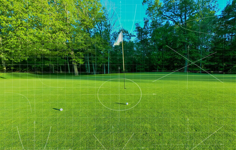
No gray area: A little rusty on the trapezoid formula or the offset method? Apps and other programs allow for easy, accurate calculations of the area of different components of the golfscape. Photo by tsg pixels/Unsplash
My appointment at the University of Arkansas is such that spring semesters are loaded with classroom time, and this year is no exception. One course that I’m currently teaching, “Turf Management Laboratory,” focuses on experiential learning, and we spend a lot of time working with the mathematics involved in all aspects of turfgrass management. At the time of this writing, I’m preparing to teach students how to measure turfgrass areas so they can determine the precise size of various tees, fairways, putting greens, bunkers, ponds and any other areas that may be managed.
Those who have had coursework on this topic may remember methods such as constructing geometric shapes and then using the appropriate formula to calculate their areas (a gold star for those who know the trapezoid formula off the top of their head), or the more sophisticated methods of “average radius,” “offset” or “modified offset” for determining the areas of somewhat circular areas (putting greens), irregularly shaped areas (bunkers) or inaccessible irregularly shaped areas (ponds), respectively.
Calculating area: The hard way
These are not my favorite items to teach, mainly because I only think about them once every two years, when teaching this class, and the offset formulas are not terribly intuitive, so I’ve always had to relearn them myself before teaching the class — and who’s got time for that?
For those itching to know, the offset methods rely on constructing a longitudinal line along the length of an object and several regularly spaced transect lines that cross the longitudinal line at 90 degrees and span the object. This essentially creates a bunch of trapezoids within the object, and a shortcut formula can be used to calculate the total trapezoid areas (after carefully measuring the length of all of those lines!) by multiplying the sum of all offset lines by the distance between them.
Ugh. And that’s why I’ve had to relearn this every two years. It’s complex and not something I use regularly. If you geek out over this type of stuff, I highly recommend the book “The Mathematics of Turfgrass Maintenance” by Nick Christians and Michael Agnew, or a great extension publication, “Practical Math for the Turfgrass Professional” by Aaron Patton.
Calculating area: Make it easy
The reason I don’t use these formulas outside of Turf Management Laboratory is because there is a much easier way to measure turf-related areas that is quicker and more accurate and does not require dragging around measuring tapes. In fact, it’s not even necessary to drag your own self to the area to be measured if you use either a smartphone planimeter app or Google Earth to do the job. (A planimeter — pronounced play-NIM´-e-ter or pleh-NIM´-e-ter — is an instrument for mechanically measuring the area of a plane figure.)
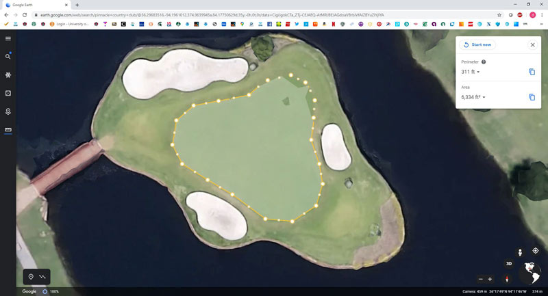
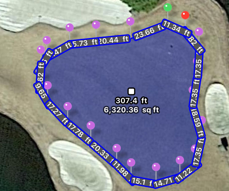
Figure 1. Measuring the island green at Pinnacle Country Club in Rogers, Ark., using Google Earth (top) and the Planimeter iOS app. There is 99.8% agreement between the programs in the square footage of this putting green. Images by Doug Karcher
These higher-tech options work simply by using satellite imagery and built-in tools for image-analysis distance measurement. The user inputs the address or the geographic coordinates of the site to be measured in order to load and then zoom in on the area of interest. The user then inserts points (or pins) along the perimeter of the measurement area. When the entire perimeter is covered, then the initial point is selected to complete the area to be measured (Figure 1, above). Measurement accuracy is improved by using a greater number of points around the perimeter of the area, especially for irregular shapes.
The accuracy of these devices can easily be verified by finding and measuring an area of known dimensions, such as a tennis court or marked football field. My go-to app for iOS, Planimeter, is reliably 99%-plus accurate when doing so (Figure 2, below).
In addition to the Planimeter app, Measure Map and GPS Fields Area Measure (App Store, Google Play) have versions for iOS and Android that are free or pro versions. The free versions come with some advertising annoyance and limitations on the number of pins that can be used to measure an area, or the number of unique areas that can be measured and saved. The pro versions typically cost just a few dollars and allow for unlimited measurement and archiving and can measure circular areas, polygons and paths and add markers to pinpoint locations. (Below, find step-by-step instructions for using Google Earth and the Planimeter app.)
Gadgets, gizmos and old-fashioned methods
These more high-tech area measurement tools are always fun to demonstrate in our “Gadgets and Gizmos” seminar at the Golf Industry Show. We’ll hold contests to see who can most accurately estimate the size of a big practice green outside the conference room (the winner takes home a pair of fashionable stress-detection glasses), and it’s always impressive how many seasoned turf managers can get within a few square feet with just their eyeballs.
One of my favorite seminar memories is being challenged by a group from St. Andrews to measure the 18th green at the Old Course. Within a minute, we had an estimate of 1,450 square meters from several thousand miles away using the Planimeter app. This value was verified as accurate by our Scottish friends.
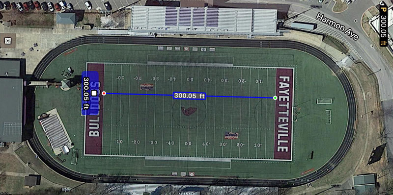
Figure 2. Satellite imagery-based area measurement is accurate, as demonstrated here by measuring goal line to goal line on the Fayetteville (Ark.) High School football field. The Planimeter iOS app was off by less than 1 inch over a 100-yard span. Image by Doug Karcher
So, because this newer tech for area measurement is so efficient and readily available, I’ve decided to put the offset methods on a shelf with the slide rule, abacus and powdered wig.
Sure, I’ll mention the formulas in Turf Management Lab class, but we’ll focus more of our class time on how to use Google Earth or planimeter apps to get the job done quickly and accurately.
There are times, however, when high-tech area measurement may not work. Situations where it may still be necessary to pull out the measuring tapes include areas of interest that are not clearly visible by satellite imagery — perhaps underneath a tree canopy — or areas that have been newly constructed and are not included in the latest satellite images available to Google Earth or the planimeter apps. For these situations, you may have to dust off your turfgrass math notes and relearn the offset formulas.
Use Google Earth to measure area
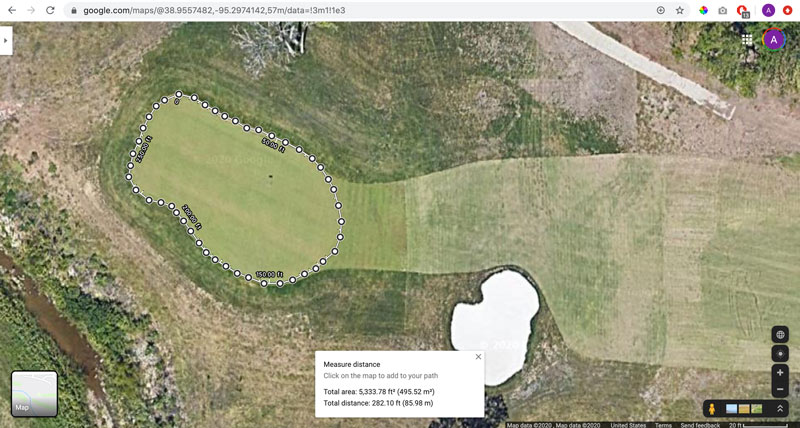
• Go to google.com/earth in your internet browser and select the “Launch Earth” button.
• Select the search icon on the left side of the screen, and enter the name of the facility, the street address or the geographic coordinates of the location containing the area to be measured.
• Use the mouse to drag the image to the center of the area to be measured, and then zoom in using the “+” button or mouse wheel to increase measurement precision.
• Click on the ruler icon on the left side of the screen to begin the measurement process. The mouse pointer will turn into crosshairs.
• Click on the perimeter of the object with the crosshairs, and move around the perimeter clicking along the edge. Click more frequently along the area’s perimeter where it is curved or jagged.
• Click on the starting point to enclose the area and get a final perimeter and area measurement.
• Select the drop-down arrows next to the perimeter and area values to change the units (several imperial and metric options are available).
Use the Planimeter app to measure area
• Download Planimeter from the App Store and launch.
• Select the “+” button to measure a new area.
• Select the search icon and enter the name of the facility, the street address or the geographic coordinates of the location containing the area to be measured.
• Swipe the screen to move the image so that the area to be measured is centered. Place two fingers on the screen and move them apart to zoom in on the image to improve measurement accuracy.
• Move the image slightly as necessary so that the perimeter of the object to be measured is directly behind the circular target in the middle of the screen, then select the “pin +” button.
• Move the image so that the perimeter remains directly behind the target, and continue to add pins. Add pins more frequently along the area’s perimeter where it is curved or jagged.
• After the entire perimeter has been traced with pins, select the green check mark to complete the measurement.
• Select the gear-shaped settings button to change the perimeter and area units (several imperial and metric options are available).
Doug Karcher, the primary author of this installment of “What the Tech?”, is a turfgrass soil specialist and professor, Mike Richardson is a professor, and Daniel O’Brien is a program technician in the Department of Horticulture at the University of Arkansas in Fayetteville, Ark.